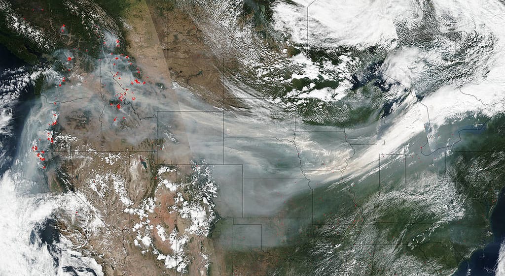
Eyes in the Sky: How Satellites, Drones, and AI Are Revolutionizing Wildfire Response
The acrid smell of smoke and the orange glow on distant horizons have become all too familiar sights across the globe. As wildfires grow more frequent and devastating—with 2023 seeing over 56,000 fires burn 2.6 million acres in the United States alone—emergency responders are turning to an unlikely trio of allies: satellites orbiting hundreds of miles above, drones buzzing through smoky skies, and artificial intelligence systems that never sleep.
This technological revolution in wildfire management isn't just changing how we fight fires—it's transforming how we predict, detect, and respond to them before they spiral out of control.
The Race Against Time: Why Every Minute Matters
Traditional wildfire detection methods have relied heavily on human spotters in fire towers and aircraft patrols, systems that can miss crucial early-stage fires or delay response times by hours. In wildfire suppression, those hours can mean the difference between containing a small blaze and watching it explode into a mega-fire that consumes thousands of acres.
Enter the new generation of fire-fighting technology that operates 24/7, processing information faster than any human team could manage.
Satellites: The Ultimate High Ground
Space-based monitoring has emerged as the backbone of modern wildfire detection. NASA's MODIS (Moderate Resolution Imaging Spectroradiometer) satellites can detect thermal anomalies as small as 1,000 square meters—roughly the size of two basketball courts. These satellites complete a full Earth scan twice daily, providing continuous global fire monitoring.
But the real game-changer comes from newer, more nimble satellite constellations. Companies like Planet Labs operate networks of small satellites that can revisit the same location multiple times per day, offering near real-time monitoring capabilities. When combined with thermal infrared sensors, these systems can detect fires within minutes of ignition.
The European Space Agency's Copernicus Emergency Management Service has already demonstrated the power of this approach, providing rapid fire mapping services that helped coordinate responses to major wildfires across Europe, including the devastating blazes in Greece and Portugal.
Drones: The Fearless First Responders
While satellites provide the big picture, drones offer unprecedented close-up intelligence. These unmanned aircraft can fly directly over active fire zones—areas too dangerous for piloted aircraft—gathering high-resolution imagery and real-time data about fire behavior, wind patterns, and terrain conditions.
California's CAL FIRE has integrated drone technology into their standard operations, using thermal-equipped drones to map fire perimeters with accuracy within three feet. During the 2022 Fairview Fire, drones provided continuous overnight monitoring when traditional aircraft were grounded, helping incident commanders make critical resource allocation decisions.
Advanced drones can now stay airborne for over 24 hours, equipped with multiple sensor types including thermal cameras, standard optical cameras, and even air quality monitors. Some experimental models can drop water or fire retardant on small blazes, potentially stopping fires before they require full-scale suppression efforts.
AI: The Brain Behind the Operation
Perhaps the most revolutionary element is how artificial intelligence ties everything together. Machine learning algorithms can analyze vast amounts of satellite and drone data to predict fire behavior with unprecedented accuracy.
Google's AI-powered fire tracking system now provides real-time fire boundary maps to emergency responders across the United States, processing satellite imagery to deliver updates every 15 minutes. The system has mapped over 8 million acres of active fires, helping coordinate evacuations and resource deployment.
AI systems can also predict where fires are likely to start. By analyzing weather patterns, vegetation moisture levels, historical fire data, and human activity patterns, these systems provide early warning alerts to at-risk communities. Australia's CSIRO has developed AI models that can predict fire risk up to six months in advance with 80% accuracy.
The Human Element Remains Critical
Despite these technological advances, experts emphasize that technology enhances rather than replaces human decision-making. Fire behavior remains complex and unpredictable, requiring experienced firefighters to interpret data and make strategic decisions.
The most successful deployments combine high-tech monitoring with traditional firefighting expertise, creating hybrid command centers where satellite feeds, drone imagery, and AI predictions inform human commanders who understand local conditions and firefighting tactics.
A New Era of Fire Management
As climate change continues to intensify wildfire seasons worldwide, this convergence of satellite monitoring, drone reconnaissance, and AI analysis represents our best hope for staying ahead of increasingly dangerous fires. The technology isn't just about fighting fires anymore—it's about preventing catastrophic blazes through early detection and rapid response.
The sky-high perspective these technologies provide is literally giving us a new way to see and understand one of humanity's oldest adversaries. In the battle against wildfires, having eyes in the sky might just be our greatest advantage.
